- Public Park
The South Devon Railway reached Newton Abbot in 1846 and from 1846 onwards considerable building took place, largely under the direction of the Courtenay family. Courtenay Park was planned as part of the eastern expansion of Newton Abbot and was laid out in 1854. The park is bordered on three sides with pleasant stuccoed houses in a variety of architectural styles, but mostly Italianate, the majority of which are listed. The landscape design of the park was planned with the surrounding buildings and provides the setting for them. The expansion continued to the east with Devon Square which is of the same date.
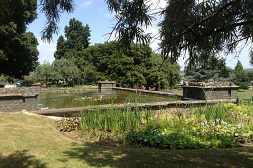
Historic maps of Newton Abbot clearly illustrate how the park has developed. Courtenay Park is depicted on the first edition Ordnance Survey (OS) map of 1890. There is a perimeter path and a central path with linking paths crossing a central axis. To the east is marked Courtenay Nursery with associated greenhouses to the north. It is not clear if this nursery served the park. On the 1905 OS map (second edition) a fish pond has been added to the south-west corner. There is no third edition OS map. The 1939 OS map (fourth edition) includes the addition of a bandstand to the west of the fish pond, a bowling green and pavilion to the south, and public conveniences to north. A recent site visit revealed that the greenhouses and nursery had been removed, an electricity sub station had been added to the south, and a sensory garden and playground added to the east. It is clear from the maps and the architectural styles that the park had some remodelling in the Edwardian period with the addition of the fishpond, bandstand, public conveniences and possibly the bowling green and pavilion. The park was then altered again in the late C20 with the removal of the nursery and the addition of the sensory garden and playground; this may have coincided with the refurbishment of the bandstand in 1995.
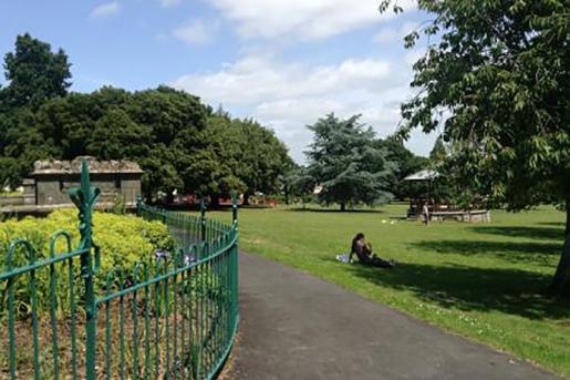
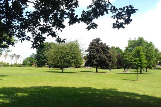
Courtenay Park has an egg shaped plan and the park slopes upwards to the west. Mid-C19 villas surround the park to the north, west and south and all but Park House to the centre, are listed at Grade II. The main entrance to the park is opposite Newton Abbot railway station and leads onto the central path to the park. The main central path was historically aligned with the railway station building, but has been narrowed at its entrance and the focus reduced since the building of the new station buildings in the early C20. There are eight further entrances around the perimeter of the park. The path layout consists of a perimeter path and a central path from east to west which divides into three at the centre of the park. These three paths lead to the upper western slopes and to the neighbouring Devon Square. The nature of the topography emphasises the buildings at the top of the slope where views over the wider landscape are obtained. To the south-west corner and at the highest point of the park is a rectangular, formal fish pond which frames views across the park and the Teign valley. The fish pond is early C20 with a buttressed granite wall to the east and wrought iron railings to the west. In front of the fish pond to the east is an early C20 iron bandstand on a coursed granite stone base, with scallop shell motif decoration. Other structures within the park include the pavilion to the bowling green at the south-east corner and the public conveniences to the north-east end. There is a modern sensory garden and a playground to the east. The Courtenay Nursery to the east of the park has been removed and the main shrub and planting beds which are now located here appear to be late C20. The trees are a mixture of mature and semi mature and line the perimeter of the park and the crossing paths. The perimeter trees now screen many of the buildings, allowing glimpses of certain buildings and providing a sense of enclosure to the centre of the park. The trees include Holm Oak, Lucombe Oak, Lime, Beech, Monterey Pine, Horse Chestnut, Wellingtonia and English Oak and Sycamore. Most of these trees were probably planted when the park was laid out. Semi-mature and younger trees dating from the C20 are scattered along the perimeter and the main pathways and include Copper Beech, Ornamental Cherry, Blue Atlas Cedar, Ginkgo and Dawn Redwood.
Courtenay Park has mid-C19 origins and as a park with a main phase of development in the period between 1820 and 1880. Courtenay Park was created in response to the coming of the railway and the expansion of the town, and is essentially part of a town planning scheme. The planned ensemble is of clear local importance and is an essential landscape setting to the surrounding Grade II villas affording them views across the park and beyond to the Teign valley. The park clearly makes an important contribution to the Conservation Area. However, whilst the park has clear group value with the listed villas there are no designated assets within its designed landscape. The park was not designed by a nationally renowned landscape architect and its layout is fairly standard and does not display any significant or unusual design qualities. Therefore, on balance, despite retaining elements of its original landscape such as its path layout and some of its tree planting, it has been altered and it lacks special interest in the national context. In a national context, the design of Courtenay Park is not of sufficient interest to merit designation. However, on a local level it is an interesting survival adding to the character and interest of Newton Abbot, as confirmed by its inclusion in the Newton Abbot Conservation Area.
It is an interesting mid-C19 park forming an essential landscape setting to the irregular crescent of Grade II listed villas but it lacks design quality in the national context It is not associated with a nationally important landscape architect nor does the park contain any designated assets However, Courtenay Park remains of local significance as confirmed by its inclusion in the Conservation Area and the Devon Gazetteer.
N. Pevsner, Buildings of England. Devon (1989) 593