- Public Park
- C18
The Lawns was laid out as a linear urban park alongside the stream from the early 1800s as part of the development of Dawlish as an elegant seaside resort. Dawlish Water began to attract visitors at the end of the C18. The Gentleman's Magazine described it in 1793 as 'A bathing village where summer lingers and spring pays her earliest visits'. In 1803 the stream was straightened so that it ran through a broad lawn. The Strand and Brunswick Place were laid out on either side. The layout, which remains remarkably intact, disregarded the sea entirely, unlike later resorts.
The Lawn complements the historic buildings in The Strand and Brunswick Place, which visually contain the space and provide an attractive backdrop to The Lawn; in return the park enhances the setting of the listed buildings and gives Dawlish its distinctive character.
The Lawn has been considerably altered throughout the C19 & C20, losing some of its original features; the bandstand is mid C20 and is of little architectural merit, and together with the large expanse of tarmac surrounding the bandstand, detracts from the appearance of The Lawn.
Towards the end of the C18 coastal towns started to become popular tourist destinations as George III 'extolled the virtues of fresh sea air and the healing qualities of the sea itself. Dawlish became such a coastal destination and many visitors to Dawlish seasoned there for the summer, leading to the gentrification of the area with the erection of Georgian villas.
In 1803, the local businessman, John Manning, decided to improve the land either side of the stream, Dawlish Water. This contributed to the development of Dawlish as an elegant seaside resort. Dawlish Water was straightened and the marsh land drained and landscaped. Two streets: The Strand (north) and Brunswick Place (south), were laid out on either side and several bridges erected. The park also had a rockery by F. W. Meyer (1807-10) which has since been demolished, but it was rebuilt in 2006-7 by Teignbridge District Council. In 1810 flooding destroyed the lawns and banks to the stream as well as two houses on Brook Street (west) and eight bridges. The stream was re-channelled and weirs were added to prevent flooding. It is unclear who designed Dawlish Water Park but it is likely to have been a local designer, and the park was probably first opened between 1803 and 1810. The park would have originally afforded views of the sea but this view was interrupted in 1846 when the railway station was erected.
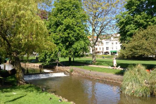
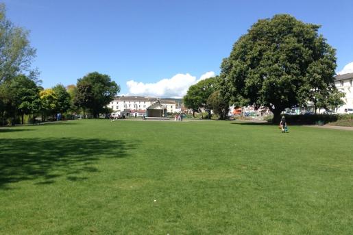
Historic maps of Dawlish clearly illustrate how the park has developed. Dawlish Water Park is depicted on the Dawlish Tithe Map of 1840 and includes the broad lawn to the north of the stream, the smaller garden to the east and the gardens to the Manor House to the west. There is a lawn terrace to the west of the broad lawn. On the first edition ordnance survey (OS) map of 1890 the eastern garden is named Tuck's Plot and the section of the stream includes a fountain and a weir. The fountain was erected in 1881 by Richard Early. The bridge dividing Tuck's Plot from the broad lawn is named Brunswick Bridge. The broad lawn is divided into three sections the Lower Lawn, Middle Lawn and Upper Lawn. To either side of the lawn is an avenue of trees. There are two footbridges over this section of the stream, both unnamed and the stream is marked as 'waterfalls'. Dawlish Water then continues east past houses to the north and a gas works to the south. The gardens open out again at The Manor House where there is a rosary and more densely planted trees to the south and a further series of weirs and footbridges to the stream, and again more densely planted trees to the north. On the second edition OS map of 1905 the garden to the east is renamed York Garden and Brunswick Bridge renamed Jubilee Bridge. To the lower lawn a shelter has been added and between the middle and upper lawn is a circular bandstand. To the manor house gardens most of the trees have been removed and the plot for the rosary survives but it is no longer labelled. Comparison between the 1890 and 1905 OS map suggests that Dawlish Water Park underwent some re-modelling, possibly for Queen Victoria's Diamond Jubilee celebrations in 1897. By 1933 (see OS map) considerable changes had been made which included the addition of a putting green to York Garden; the erection of public conveniences, a shelter and a meteorological station; the removal of trees to the avenues and the addition of a tennis courts to the middle lawn and a bowling green to the upper lawn. Further changes occurred throughout the C20 to both the lawns and the gardens to the Manor House further west. The Lawns is a linear shaped park laid out along the course of the stream, Dawlish Water, and runs inland for c.1km in a westerly direction. The urban park is located to the centre of the seaside town of Dawlish and is approached through a series of entrances around the perimeter of the park. At the east end is York Gardens which includes a fountain to the centre of the stream. To the west end of York Gardens is Jubilee Bridge (Grade II), a single span bridge built of ashlar with an elliptical arch with a dated keystone of 1887. It has a cast iron balustrade with a design of pierced circles. To the west of the bridge are the broad lawns to the north of the stream. These lawns include a mid-C20 bandstand to the centre; two C20 shelters and public conveniences to the east end; covered seating areas to the north and a bowling green to the west end. To the west end is a narrow stretch of the park leading from the lawns to the gardens to the Manor House. These gardens are in an undulating landscape which is largely laid to lawn with some trees. There is a play area to the south-east, a pond to the north-west and a block of flats to the west. The stream retains its artificial weirs across its length and the park retains some historic features including stone revetments, fountains and bridges. The path layout also appears to remain largely intact.
The gardens were originally laid out on marshy ground which means that it is unlikely that tree planting was part of the original scheme to the lawns. The line of horse chestnuts bordering the path to the north and the surviving oaks are therefore likely to date from the late C19. Later C20 shrub planting occurs along the historic pattern of the planting beds around the periphery of the open lawns. The gardens at the Manor House are largely overgrown but include some mature trees including a Monterey Pine, Holm Oak, Monkey Puzzle and Yews. Other mature C20 trees include willows and poplars along Dawlish Water.
The Lawns at Dawlish was created in response to the increased fashionability of Dawlish as a coastal town and to meet the needs of the gentrified classes who seasoned there. It clearly provides Dawlish with an identity and a sense of place and forms the centre and focus of the Conservation Area, but it is of local rather than national significance. Although early C19 in date it is not designed by a nationally renowned landscape architect and is standard in its design rather than influential.
The Lawns at Dawlish retains elements of its original landscape such as its path layout and stone revetments to the stream. However, the park has been continuously altered throughout the C19 and C20. The alterations to celebrate the jubilee add interest but they do not wholly survive and features such as the bandstand have been replaced or lost. Other significant losses include the stone pillars with urns to the central axis and the loss of the park's relationship with the sea as the view has been obscured by Dawlish Railway Station. Furthermore, the buildings and structures within the park, with the exception of Jubilee Bridge, do not exhibit any architectural merit and therefore the park lacks group value.
When Dawlish Water Park is compared to registered parks such as the Spa Gardens, Royal Leamington Spa (Grade 11) it is clear that it does not meet the criteria for registration. The Spa Gardens, whilst not in a coastal town are located in a spa town and therefore was a popular destination for its perceived health benefits. It is also a linear park with early-C18 origins which follows the course of a stream. However, it also includes a number of listed buildings and structures and therefore has clear group value; it retains much of its original layout and planting; and has a well documented history which supports its claims to special interest. Dawlish Water Park lacks the overall designed landscape interest of The Spa Gardens and is instead rather standard in its design and has suffered from alteration. Pevsner, Buildings of England. Devon (1989) 229-230
In a national context, the design of Dawlish Water Park is not of sufficient interest to merit designation. However, on a local level it is an interesting survival adding to the character and interest of this seaside town, as confirmed by its inclusion in the Dawlish Conservation Area. Reasons For Designation Decision: Dawlish Water Park is not recommended for registration, for the following principal reasons: It is an interesting early C19 park but it lacks design quality and does not retain enough of its original landscaping It is not associated with a nationally important landscape architect * The park has been significantly altered and has lost its relationship with the sea and many of its C19 architectural features including its C19 bandstand and stone pillars with urns * However, Dawlish Water Park remains of local significance as confirmed by its inclusion in the Conservation Area
Cherry & Pevsner: The Buildings of England – Devon, 1989: 329