- Gardens
- C19
The estate occupies about 20 acres in an approximately triangular shallow valley,running down from Babbacombe Road to the top of the steep descent into Anstey’s Cove.Anstey’s Cove Road divides the main ornamental grounds from the former walled gardenand wooded walks. The coastal path crosses the bottom corner of the estate and a publicfootpath runs along the southern boundary.
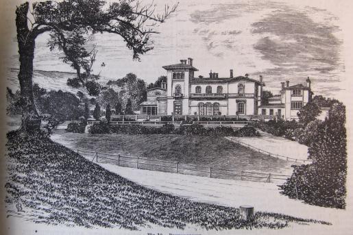
The mansion was built in 1841 for Bishop Henry Phillpotts, Bishop of Exeter 1831 –1869. The architect was Mr. Gribble of Torquay. The three terraces from the garden frontwith a fountain on the lowest one were shown in a lithograph published by E. Cockremand displayed in the present building. The setting was open lawn, framed in the picture by the rugged valley leading to the sea.
After the bishop’s death in 1869, the building passed to Sampson Hanbury, ownerof a brewery firm in Birmingham. 37 years later the ownership changed to Sir Arthur &Lady Elizabeth Havelock. They had previously rented Kilmorie & Cockington Court. Itwas sold in 1920 and in 1921 it opened as an hotel owned by Mr. G. W. Hands. Two large wings and an extension were added. A swimming bath was opened in 1928 and replaced in 1978. The indoor tennis courts were an important facility from November 1936 and the golf course was laid out in the 1930s. During WWII it was a hospital for RAF officers until bombed in October 1942 with 19 deaths. In January 1943 it was bombed again while being renovated and did not reopen as an hotel until 1948. Political party conferences became a feature. It is still an hotel with an additional wing and leisure facilities.
The 1861 OS map shows the mansion and formal central terraces, plus further terracing planted with trees and running SW from the top terrace. The site is enclosed in a shelter belt of trees, through which runs a peripheral path. Specimen trees occupy the northernmost area of the rear garden. The rock outcrop in front and NW of the mansion is tree-covered and the drive is as the present N-S curve. The l ower bridge is shown, leading to woodland walks along the cliff.
An article in JHCG in 1876 included a drawing of the house and two terraces. The brief description of the ‘dressed grounds’ of four and a half acres and kitchen garden of one and a half acres comments with surprise on the good selection of conifers. A separate article gave details of the bedding in the formal terrace beds. The northern half of the total site was mapped in 1887 and showed ranges of glass
immediately north of the mansion. There may have be a bridge from these across Anstey’s Cove Road to the walled productive garden, shown with a SE-NW dividing wall. The NE section is divided into four by cross paths and a small building in the NE corner. The SW area is split in two and there are trees inside the NE facing wall. To the NW the triangle of land contains a pair of houses and a square of six trees with ornamental trees along the western boundary. A drinking fountain label probably belongs to the bulge in Anstey’s Cove Road. There is very little change in the 1904 2 nd OS. The croquet lawn appears to be in place and there are minor variations in the trees and paths indicated. By the 1933 3 rd OS the hotel is in a much expanded building and more buildings have replaced the glass. There are glass buildings (conservatories?) either side of the southern extension in place of the open terraces. The SW section of the walled garden contains two tennis courts There is a large building in the east of the walled garden and two glasshouses on the NE & NW walls. Babbacombe Road has been built up along the other side.The front of the hotel retains the curved drive and the rock outcrop with mature trees. Lack of time prevented a visit to the separate northern area but signs indicated that the northern part was occupied by exercise and leisure facilities. The SE woodland walks from the lower bridge were reported to persist, with the coastal path just outside the hotel boundary.Within the main garden, the terraces are still extant though probably rebuilt after the bombing. The planting is well maintained and includes tender shrubs as well as formal bedding. A grass slope below the terraces stops at a square of wide gravel paths, not actually linked to any other path and so giving an isolated effect. Within this is a formal pattern of rose beds, attractive when viewed from above and softened by shrub planting around the edges. There is another isolated feature of a fountain within a large circular pool on the initial slope of the southern side valley, which could be the original one from the lower terrace.
The whole site is damaged by the presence of a small golf course occupying the T-shaped lowest grass area. However beyond the first tee and an incongruous group of bears carved from a tree-stump, outstanding mature trees, especially conifers, dominate the northernmost area. There is still a croquet lawn close to the hotel’s northern extension. The periphery path has been recently renewed on the northern side but appears to follow the original line and diverges to the lower bridge. At the eastern point of the estate there is a viewing terrace looking north towards Oddicombe bay and access to the
public car park, coastal and cove paths. The hotel path follows the southern contour back inland within the shelter belt. The path is composed of rough rubble stones and is difficult to walk on except where softened by a carpet of moss. This means that everyone walks on the edge of the golf course grass instead. There are attractive views back to the hotel and formal gardens from the path beneath mature trees, including ilex (holm oak). This path appears to end abruptly, as it did in the early 20C. However the same attractive style of path through the shelter belt follows the inside of the wall along Babbacombe Road from the head of the side valley back to the hotel. There is a small stream flowing down this valley to the fountain at the bottom with a bridge at the top end for golfers.
Todd Gray, A Garden History of Devon
Arthur Charles Ellis, An Historical Survey of Torquay, (Torquay Directory: 1930)
John Pike, Torquay: the place and its people, (Centenary Committee: 1992)
Journal of Horticulture and Cottage Gardener, vol. 56 (3 August 1876) pp. 98-9, 115.